9.20.2009

Tai Rom Yen National Park ( Surat Thani National Park )

Tai Rom Yen National Park situated in Surat Thani Province, in the past Khao Chong Chang was an area of communism, and other special events are an area to assassinate of Vibhavadirangsid Prince in helicopter, and to kill Surat Thani's governor assistant, at last can banditry by solder with Tai Rom Yen military operation, next there are announce to national rhinoceros.

Geographical Features

The area consists of complicated mountain range, and is the source of water. Its main rivers are Chawang River, Lamphun River, ์Namtao River and Tan River for examples, and some mountains are limestone so that cause the area has many wonderful caves.

Weather Condition

The weather in the area has two seasons, which are rainy season from May to December, and summer from January to April.

Tai Rom Yen National Park Varieties of Plants and Wild Animals

Location and Journey

Tai Rom Yen National Park
, Ban Na San, Surat Thani, Thailand 84120
Tel. : 0 7791 8611 (VoIP) 08 9893 6455 0 7734 4633 Fax : 0 7734 4633
Head's name : Sukrid Krataichan Position : Technical Forest Officer 7

By Car

From Surat Thani Province along highway 4009 (Surat Thani - Ban Nasan) about 30km to Ban Chiang Phra, then turn left opporite to Khuan Suban School for further 15km to the National Park and Dat Fa Waterfall. Total distance about 45 km.

By Airplane

By Thai Airline Public Co, Ltd. from Bangkok to Surat Thani province, and take a bus to park headquarters

By Train

Use the train everyday from Bangkok to Punpin Train Station, and take a bus to park headquarters.

Tai Rom Yen National Park general Information

Tai Rom Yen National Park situated in Surat Thani Province, in the past Khao Chong Chang was an area of communism, and other special events are an area to assassinate of Vibhavadirangsid Prince in helicopter, and to kill Surat Thani's governor assistant, at last can banditry by solder with Tai Rom Yen military operation, next there are announce to national rhinoceros.

Geography

The area consists of complicated mountain range, and is the source of water. Its main rivers are Chawang River, Lamphun River, ์Namtao River and Tan River for examples, and some mountains are limestone so that cause the area has many wonderful caves.

Climate

The weather in the area has two seasons, which are rainy season from May to December, and summer from January to April.

Tai Rom Yen National Park

Thailand holidays : Tai Rom Yen National Park ( Surat Thani National Park )

Tai Rom Yen National Park

Hat Noppharat Thara - Mu Ko Phi Phi National Park (Krabi National Park)

Historical

Wai King Cave In the northeastern part of Phi Phi Le Island, is the location of the Waiking cave where the King Phumiphol Adulyadej had been here and gave the new name as "Phaya Nak Cave" because there is one stone looked like the head of naga which local people who collect the nests of swallow birds pay their respects. In this cave, eastern side and southern side, you would find the historical paints of elephant and many kinds of boats pictures.

Beautiful Nature

Shell Cemetery (Susan Hoi)
This is the miracle of nature which took place on the ancient age, 75 million years ago when many kinds of freshwater shell had been starved as a huge fossil, so called the cemetery of shell or "susan hoi" in Thai language. After carefully measurement and analysis by a new technology, we found that this shell cemetery is actually 40-20 million years of age.

Hat Noppharat Thara - Mu Ko Phi Phi National Park Noppharat Thara Beach Formerly, it's so called " Khlong Hang" because after the water from the northern mountain is gone, it would leave only a long sand beach which end at Ko Khao Pak Khlong. This area is the world biggest house of a "hoi-chak-tin" or "feet-pulling shell"

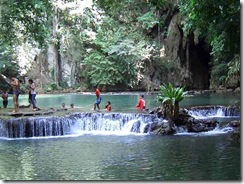
Nang Bay There is a colorful view diferent from other beach because one side of the beach is a mountain which has a stalactite cave, so called Tham Phra Nang. It's very quiet here, so many tourists love to visit and stay here.

Poda Island Located at the southern part of Phra Nang Bay. From the shore, you can see the white sand beach and many kinds of coral because the sea in this area is very clear. This's very attractive for tourists which they can visit here for almost year long.

Hat Noppharat Thara - Mu Ko Phi Phi National Park 
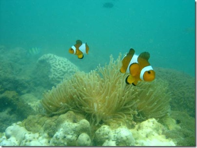
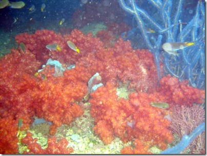
Mai Phai Island Located in the northern part of Phi Phi Don island, not far away from Yung island. Northern side and eastern side has a beautiful beach and coral reef which most of them are the staghorn coral, laid along to the southern part of island.

Yung Island Located in the nothern part of Phi Phi Don island, you can find the rock beach on the eastern side here and also a small sand beach located in the alley of mountain. In addition, you would find the varieties of beautiful fertile coral reef here.

Phi Phi Le Island Phi Phi Le covers area about 6.6 sq.km. It is the island of limestone mountains consisting of a steep high cliff vertically with the sea surface. Around this island has a sea area with depth about 20 meters. There are many beautiful gulf areas such as Pi Le Bay, Maya Bay, and Lo Sa Ma Bay.

Hat Noppharat Thara - Mu Ko Phi Phi National Park Phi Phi Don Island Phi Phi Don is located about 28 sq.km. Laem Tong Cape is situated at the north of the island where 15-20 families of the sea gypsies dwell. These sea gypsy migrated from Li Pe Island in Satun Province. The cape is suitable for scuba diving and snorkelling. Lam Hua Ra Ket Cape, Had Yao Beach, and Hin Pae are also very beautiful. Ton sai Bay is the most beautiful scenery of the twin bays. Accomadation can be found at Loa Adam. This beautiful picture was been taken 10 years ago where settlement was absent.

Nature Education

Ngon Nak Mountain Nature Trail

Facilities

Accommodation Bungalows are also available.

Camping site There are the camping area with a parking lot, bathrooms and restrooms for serving tourists at the area of Ko Mai Phai Ranger Station.

Food services Restaurant is available in the Park.

Souvenir shop 5 souvenir shops : Ao Phra Nang area, Ao Railey, Hat Nopphrarat Thara, Susan Hoi and Phi-Phi Don.

Hat Noppharat Thara - Mu Ko Phi Phi National Park Docking , Boat Tie-up , Wharf It has 7 ports for parking boats : Ao Phra Nang port, Ao Railey port, Ko Kwang port, Khlong Yingsuea port, Khlong Son port, Hat Khlong Muang port and Ao Nammao port.

Visitor center The office of National Park can serve you with a multimedia tools. You may see the exhibition at the Susan Hoi Ranger Station, Ko Mai Phai Ranger Station and the Railey Information Service Center. This gives you both natural touch and knowledge.

The Royal forest department had surveyed and established the 75 million-year shell cemetery (Susan Hoi), Hat Noppharat Thara - Mu Ko Phi Phi and near-by islands in Nong Thale sub-district, Ao Nang sub-district, SaiThai sub-district and Pak Nam sub-district of Amphoe Mueang Krabi, 389.96 sq.km, as the 47th National Park of Thailand so called "Hat Noppharat Thara-Mu Ko Phi Phi National Park". There after, it had been expanded to cover the shell cemetery and near-by islands, 0.02 sq.km. After that the area of Nong Thale sub-district, Amphoe Mueang Krabi, Krabi province which is the area of the Royal Thai Navy and the Royal Palace area has been excluded from this national park and left only 387.90 sq.km.

Hat Noppharat Thara - Mu Ko Phi Phi National Park Geographical Features

Consists of the land area on the coast of the island such as Ao Nammao mountain area, Ao Nang-Hang Nak forest and other islands. The geological form of this area is the high mountain laid along the northwest-southeast direction. Coast area is the high mountain while the western side has deeper slope than the eastern side. Geological form of sea coast area and islands in Andaman sea would be affected by the line of earth layer movement so called "Indosenia Teotonic Movement". At the area of mangrove forest of Hang Nak mountain you would find the Klom mountain canal on the coast rim which get the drained water from a big pond, so called "Nong Thale" (Sea Pond) and originates the mangrove forest and low plain area of the Samed forest in the area of national park office namely "Khlong Haeng" (Noppharat Thara Beach).

Weather Condition

"Hat Noppharat Thara - Mu Ko Phi Phi National Park is influenced by tropical monsoon wind. During November-October would has the southeastern-monsoon wind drives through and induces to have two seasons of weather here; the first is raining season starts from May till December and the hot season starts from January till April. Average temperature here is about 17 - 37 degrees celsius. Average rainfall per year is about 2,231 milimeters which would be highest in July and lowest in February.

Hat Noppharat Thara - Mu Ko Phi Phi National Park Varieties of Plants and Wild Animals

Vegetations in the national park area could be classified into 3 groups as follows :
Primary rainforest could be found in the high steep mountain. According to these are the limestone mountains which have a thin layer of soil and are frequently impacted with strong wind, lets the rainforests in this area are not naturally fertile. Most of plants are iron wood, rubber and shorea, and the low level trees such as chanpha, rattans, banyans and many kinds of vines.
Mangrove forest could be found in dry canal and Yan Saba canal. Found plants are red mangroves, samae, peninsular, withe beans, black beans, etc.
Phru forest is the society of dominant plants which found the dense samet trees in the Nhoparatanatara beach. Other found plants are shorea, jambolan plum, cogon grass, etc.
Wildlife
Animals int the Nhoparatanataral-Phi Phi Islands National Park can be classified as follows : mammals, birds, reptiles, amphibians, fishes and other aquatic animals which no spine, such as sea slug. The important one in this group is coral such as a thorn coral, cub surface coral, leaf coral, tree coral, ect.

Hat Noppharat Thara - Mu Ko Phi Phi National Park Location and Journey

Hat Noppharat Thara - Mu Ko Phi Phi National Park
79, Mu 5, Ao Nang , Muang , Krabi 81000, Muang Krabi, Krabi, Thailand 81000
Tel. : 0 7566 1145, 0 7563 7200, 0 7563 7436 Fax : 0 7566 1145
Head's name : Tanapong Apaiso Position : Technical Forest Officer 7

By Car

You can drive from bangkok on the road no. 4th, through Phetchaburi province, Prachuap khirikhan, Chumphon, Ranong, Phang Nga and Krabi which is about 946 kilometers long. The other way, you may drive on road no. 4 to Chumphon province and then change to the road no. 41 through Amphoe Langsuan, Amphoe Chaiya, Amphoe Wiangsa of Surat Thani province, then change to drive on the road no. 4035, through Amphoe Ao Luek and turn to use the road no. 4 again and drive to Krabi province which is about 814 kilometers.

By Airplane

Go by airline, from the Bangkok Airport directly fly to the airport of Krabi province.

By Train

Take a train from Bangkok to the train station of Trang province or the Phun Phin's train station of Surat Thani province or the Thungsong's train station of Nakhon Si Thammarat. After that please take a bus to Krabi province.

By Bus

Take a bus by buying a ticket at the Southern Bus Terminal. There are two bus companies, the first one is the "Transportaion Co., Ltd." and "Lignite Tour Co., Ltd.

Khao Phanom Bencha National Park (Krabi National Park)

The site is comprised of with Khao Phanom Bencha at 1,397 meter in height above mean sea level, providing watershed area for the surrounding areas of Krabi Province and then flows to Andaman sea. Phanom Bencha mountain range is layed from north to south.

Climate

The weather is warm and humid throughout the year. There are two seasons, Hot season between January to April and Rainy season between May to December, maximum rainfall is in June to October.

Flora and Fauna

As a Moist evergreen forest, fauna in the park consisting of Hopea odorata, Dipterocarpus alatus, lagerstronemia cupida, Malacca teak, Michelia champaca, Parkia speciosa, Baccarea sapida. Ground fauna found are palms, genus Calamus or Daemonothops, greenia wightiana and bamboos. There are a number of animals live in the park which generally can be found are serows, wild pigs, panthers, clouded leopards, black bears, mouse deers, langurs, gibbons, Stump-tailed monkeys, Asiatic wild dog, squirrel, iorises, white-rumped shama, hornbills, pheasants, red jungle fowls.

Mu Ko Lanta National Park (Krabi National Park)

Establised in 1990, according to the order of Mr. Chaun Leekpai, Prime Minister and Wild Animal and Plant Foundation of Thailand. It includes Ko Rok, Ko Mai Ngam Tai, Ko Ta La Beng, Ko Lanta Yai, Ko Ngai, Ko Tu Kon Lima, Ko Rok Nok, Ko Rok Nai, Ko Hin Dang and nearby islands of Ko Klang district, Ko Lanta Noi district and Ko Lanta Yai sub district, Amphoe Ko Lanta, Krabi province. It is the 62th national park of Thailand which covers area of 134 square kilometers or 83,750 rais.

Geography

Over all geographical feature is the complexity of mountains and rather deep slope. The plain area would be found only in a beach area in the southern part. Most of area here is more than 35 percent slope, except only the middle part of island where a slope is more than 50 percent. The height of this are is range from 100 meters above sea level to a heigth of 488 meters at the peak of mountain.

Climate

Most rainfall is in September which is about 391.4 milimeters and the lowest in January which is about 6.5 milimeters. Number of days of the highest raining is in September which is about 21.6 days and the lowest is in February, about 1.6 days.
In rainy season, the national park will be closed (Rok Nok Island, Rok Nai Island, and Hin Moung - Hin Deang Rock) during 16 May - 15 November every year for visitors safety.

Thailand National Parks Mu ko Lanta Flora and Fauna

There are a lot of fertile forest resources and varieties of vetgetation which could be classified as follows :

  1. Rainforest covers 19.42 square meters of Lanta Yai island, along the Lanta mountain which covers most of area of the national park. Upper level trees and middle level trees at average height about 15-25 meters are found in this forest. The important plants are L. siamica, Hopea ferrea Heim.,etc. And also the palm tree and cane wood species are the low level trees here, the important species are Fan palm, Calamus erectus Roxb., Calamus caesius Bl., Calamus peregrinus Furt.,etc.
  2. Mangrove Forest could be found in Mai Ngam island, South Mai Ngam island and Ngu island. These islands are not big and most of area is covered with the mangrove forest. Mangrove trees are tall at the same height with averange about 5 meters. Plants could be found here are Avicennia alba, Rhizophora apiculata, Rhizophora mucronata
  3. Beach Forest covers the small area between connecting area of beach and rainforest of Ngai island. The important plants are Bengal Almond, Derris indica, beach moring glory, etc.
Thailand National Parks Mu ko Lanta Wild Animals
Able to classified into 6 groups as shown below.
  1. Mammal Animals consists of 20 families 30 genuses and 38 species which 2 species had gone from Lanta island. They are wild deers and tigers, and the other species is the sea cow which is the conserved animal. The other two species that being gone are the common barking deer and fishing cat. The rarely finding animal on this island is the the marshall big ear crow bat .
  2. Birds on these islands are totally 58 families, 130 genuses and 185 species. Most easy find in this national park are Brahminy Kite, Birdled Tern, Emerald Dove , etc while the most difficult find are Orange-Breasted Trogon, Siberian Thrush, and Little Spiderhunter, etc.
  3. Reptiles, mostly are Water Monitor, Reticulated Python and Cobra , etc.
  4. Amphibians could be found two species, the first one living in canal is Giant Mountain Frog, Ornate Froglet and the second one living in building and ponds. Others amphibians in forest are Polypedates leucomystax (Gravenhorst)-1829 and Small Toads and the difficult find species is the Dorria frog.
  5. Sea and Fresh Water Fishes which could be found in fresh water ponds of the islands, fresh water fishes that you can find here such as Blue danio. While the sea fishes would be found along the coral reef, rock beach and fresh water canals such as Lizard fish and Porcupine fish, etc.
  6. Animals in the Coral Reef are Staghorn coral, Fungia fungites, Anemone coral, Starflower coral, etc.

Article Source : http://www.dnp.go.th

Ko Lanta - The most beautiful island of Andaman Sea

Thailand National Parks Mu ko Lanta Just off Thailand’s south western coastal town of Krabi, on the east side of Phang Nga Bay, exists a unique, unspoiled tropical island: Ko Lanta Yai. Ko Lanta Yai preserves its community spirit in both family and business life. With clear, cool waters and superb white sand beaches stretching along a 27 kilometer coastline, its paradisiacal appeal remains unmarred by mass tourism. The island, which reaches a height of almost 500 meters at its extreme end, also boasts a mountain range covered with rain forest.

The Ko Lanta archipelago is made up of over fifty small islands, though only three are inhabited: Lanta Yai , Lanta Noi and Ko Ngai. Lanta Yai is the most attractive to tourists, with its impressive beaches and activities for visitors. Approximately 10,000 of the regions’ 20,000 inhabitants reside on Lanta Yai. Most of Lanta Yai’s residents are practicing Thai Muslims, deriving their income from rubber farming, fishing, palm tree growing, coconut or cashew nut plantations, and the travel industry.

Thailand National Parks Mu ko Lanta The island itself runs from north to south, with the west coast established as the main tourist area, offering accommodations for all budgets, a variety of activities, and a choice of bars and restaurants. Picture-perfect sunsets can be seen from any of the many beaches, while the colorful local fishing boats known as “long tails” bob lazily in the foreground.

The east coast is far less developed, affording the curious explorer a glimpse of life outside of tourism. Facing toward the mainland, the coastline largely consists of mangroves, with yellow sand beaches towards the southern end. It’s here you will find the ancient Sea Gypsy Village, home to the indigenous settlers on Ko Lanta who live in harmony with the sea.


Article Source : http://www.lantainfo.se/en_index.htm

Than Bok Khorani National Park (Krabi National Park)

Than Bok Khorani National Park is a rainforest situated in the valley in the midst of the mountains. Streams flow through the area disappearing into the limestone rocks underneath the mountains, on their journey to the sea. The source of the stream is Nam Phut Cave and Ao Mai Dam Mountain (Black Tree Bay Mountain). This was formerly the territory of wild elephants, until people moved in and settled the area. They cleared the forest and took possession of the land for agriculture, until only the stream remained. The park was established on 30th September 1998.

Geography

Geography of Tarn Bok Koranee National Park is the ridge of mountains alternatively laying along north-south direction like a complicated wave and has varieties of deep slope. There is a little bit of plain area, most of them would be found on mountain shoulder and valley. The limestone mountains in this area are covered with the mixed tropical forest and in addition it also consistis of mangrove forest, waterfall stream, sea and beach. Morevever, there are a limestone island and many small islands, about 23 islands.

Than Bok Khorani National Park (Krabi National Park)Climate

The climate of this national park is a monsoon weather, consists of 2 seasons; raining and hot season or so called "eight raining-four sunshine" which means raining for 8 months and hot for 4 months.
Raining Season starts from April till December every year. The heavy rain would be found in September while November would be cold with an average temperature at 26.4 degrees celsius.
Hot Season starts from mid of January till April every year. February is the lowest of raining and very hot but suitable for travel. In April, the average temperature is 29 degrees celsius.

Than Bok Khorani National Park (Krabi National Park) Flora and Fauna

The national park covers an area of 104 sq.km, including a group of 23 islands off the coast of Krabi as Chong Lat Tai Island, Ka Rot Island, Pak Ka Island, Lao Bile Island (Hong Island), etc,. The landscape is dominated by a series of impressive mountains; precipitous, tall, limestone towers, protruding out of the landscape in a typical Karsts topography. Sink holes in the rock lead the way to underground streams, and numerous mountain cave. Than Bok Khorani National Park is the source and watershed for the water of Ao Luek District, flowing from five important streams; Marui, Klang, Nam Tok, Ao Luek and Ka Rot.
The main plant communities are rainforest, mangrove forest, and freshwater swamp forest.
Rain Forest is found on the steep mountain ranges, Hopea spp., Lagerstroemia spp., Dipterocarpus alatus, Intsia palembanica and Terminalia wallichiana being the dominant trees, and the undergrowth is characterised by Salacca sp., rattan and bamboo.
Mangrove Forest is mostly found around Tham Rot Tai Mountain, Nam Bay and Ka Rot Island. The main species are Rhizophora, Kylocarpus, Bruguiera, Sonneratia and Avicennia.
Swamp Forest covers the footslopes of Chong Lom Mountain. Because the forest no longer covers a wide, continuous area, the variety of wildlife is reduced.
Than Bok Khorani National Park (Krabi National Park)Wildlife
Mammals, include Wild boar, Fishing Cats, Mouse Deer, Gibbon, Langurs, Large Indian Civet, Malayan Porqupine, Pangolin, Otters, Squirrels, Javan Mongoose and Flying Lemurs.
Birds, include Brahminy Kite, Common Koel, White breasted waterhen, Hill Myna, Woodpeckers and Grey Wagtail. The rivers are habitat for a wealth of freshwater species, including True Eel and Long Tom.
Reptiles, such as chameleon, bengal monitor, king cobra, cobra, reticulated python, malayan pit viper, bronzeback, etc.
Fish, whilst the sea supports coral reefs, with both hard and soft corals, Parrotfish, Starfish, and Anemones. Interesting Points

Article Source : www.dnp.go.th

Than Bok Khorani National Park (Krabi National Park)

Than Bok Khorani National Park (Krabi National Park)

Than Bok Khorani National Park (Krabi National Park)

Than Bok Khorani National Park (Krabi National Park)

Hat Khanom - Mu Ko Thale Tai Nation Park ( Nakhon Si Thammarat National Park)

At present, under the process of appointment as a national park, which shall cover part of the following local: Khlong Thong, Khlong Reng, Khao Ok, Khao Thong Not, Pa Khao Chai Son, Len Khlong Khanom, Khao Fee Hai, Khao Wang, Khao Krot, Chai Kram-Wat Pradu, Khao Hua Chang Forest and 8 islands namely, Ko Mut Tang, Ko Mut Kong, Ko Rap, Ko Hua Ta Khe, Ko Wang Nai, Ko Wang Nak, Ko Noi and Ko Ta Rai, all in Sichon and Khanom District, Nakhon Si Thammarat province, and Ko Samui District, Surat Thani.

Geography

Most of the area is covered with lush primary forest which is the originating point for many creeks, from which water is used by the locals for consumption and agricultural activities. Some of the areas are of limestone mountain and quite healthy mangrove forest.

Climate

Influence from the South-Westerly wind and North-Easterly wind results in rainfall almost all year round. However, there are 2 seasons altogether, which are summer (February – April) and rainy season (May – January).

Flora and Fauna

Hat Khanom - Mu Ko Thale Tai Nation Park ( Nakhon Si Thammarat National Park) Forests in the area are:
Primary forests with valuable plants such as Intsia palembanica, Dipterocarpus sp., Ironwood, Sandoricum Koetjape and Indian Oak.
Mangrove forests with valuable plants such as Mangroves, Taboon and Thespesia populneoides.
Limestone Mountain also exists with plants such as Chanpah and Opuntia elatior.
Wildlife
Can be classified as follows:
Mammals – Sus scrofa (wild pig), Monkey, Semno, Squirrel, Menetes berdmorei (Indochinese ground squirred), Naemorhedus sumatraensis, Muntiacus muntjak, Ursus malayanus, Tiger, Barking deer, Gibbon and Malayan sun bear.
Birds – Spilornis cheela (Cnested), Treron curvirostra (Thick-Billed Pigeon), Copsychus saularis (Oreintal), shama, dove, cormorant, Nicobar pigeon, seagull, Egretta sacra (Pacific Reef-Egret) and Ducula aenea (Green Impevial)
Reptiles – consists of tortoise, snakes and chameleon.
Amphibians – different kinds of frogs, Bufo asper.
Other aquatic life – Channa striatus (Sepenthead), crab, shrimp, saltwater fish, brook carp and snakehead


Article Source : http://www.dnp.go.th

Namtok Khlong Kaeo National Park(Trat National Park)

Namtok Khlong Kaeo National Park(Trat National Park)

Namtok Khlong Kaeo National Park

Most of the area consists of not much complicated mountain range such as Khaokaw Mountain Range, Tabard Mountain, Tachoat Mountain and Kampang Mountain. At the ridge of the mountains, 100-836 meters above sea level, is the border of Thai and Cambodia. The highest peak is Khaotabath Mountain Peak 836 meters above sea levels. The area is the source of canals such as Klong louk, Klong kaew, Klong hinpleang, Klong lue, Klong kajai, Klong malagor etc. Water in all of these canals flows to Klong sator and to the sea.

Climate

The weather in this area is tropical monsoon and influenced by southwestern monsoon in the rains and northeastern monsoon in winter. The area has productive forest that causes heavy continuous rain all the year round. The seasons are as follows.
Summer - starts from February to April
Rains - starts from May to October
Winter - starts from November to January

Namtok Khlong Kaeo National Park Flora and Fauna

The area consists of rain forest which is the source of rivers and has many kinds of plants such as small shrubbery and 25-60-meter tree. The valuable trees in this area are Dipterocarpaceae, Marlabar ironwood, Sterculiaceae, Meliaceae, Lagerstromeae etc. And shrubberies found normally are ginger, galangal, rattan, palmae, bamboo, fishtail palm, and areca palm etc.
The surveyed area is naturally productive forest so that makes this area has a number of animals, for example, a great number of leeches in many wet places show that the area still has a great number of wildlife too.

Article Source : http://www.dnp.go.th

Grand Temples of Thailand

As the majority of the country’s population are practicing Theravada Buddhists, one of the most prominent sights around Thailand from Bangkok to Chiang Mai are the tiered rooftops of grand temples (known as wats).

Thanks to its combination of such fascinating culture with a low cost of living, Thailand attracts thousands of backpackers each year, with numerous hostels in Thailand providing cheap accommodation for travelers exploring the country’s sights.

Bangkok

Often the first point of call for backpackers in Thailand, the hectic modern surface of the capital city, Bangkok, conceals a history that’s bound up with its numerous impressive temples.

Home to the country’s most famous attraction, the Grand Palace, Bangkok is at the heart of the Thai Kingdom and its cultural heritage. In the grounds of the Palace complex lies Wat Phra Kaeo, or the Temple of the Emerald Buddha – Thailand’s most sacred site.

Whilst the Emerald Buddha is small in size, it’s often considered to be the most important image in Thailand. Moved to its current location in 1784, legend places its origins in India with years of Southeast Asia fighting around (and over) it in between.

In addition to this celebrated image, there are paintings and figures inside the wat which depict the mythology of Ramakien, the Thai version of the Hindu epic of the hero Rama.

The giant reclining Buddha at Wat Po is a must see

Just to the south of the Grand Palace, the dazzling Wat Pho is also a popular attraction in Bangkok. The oldest temple in the city, it dates back to the 17th century and is famous for its huge reclining Buddha.

With regards to a place to stay, there are a number of hostels in Bangkok offering both cheap private rooms and dorms to travelers exploring these stunning sights. Many of the best (and most affordable) hostels are situated in Banglamphu, a hub for travelers in the city and in easy reach of the Grand Palace.

However, these temples are just part of Bangkok’s rich history – other highlights include the Wat Mangkon Kamalawat, beautifully decorated with Chinese dragons, and the large Wat Arun, one of the city’s most distinctive landmarks.

Old Sukhothai

North of Bangkok, the ruins of the walled city of Sukhothai lie on Thailand’s central plains. Easily accessible by bus via the modern settlement nearby, there are also some convenient hostels in the vicinity.

The temple ruins at Sukhothai are 600 years old

Dating back to the 13th century, the city originally housed around 40 separate temples. Today, the most important site is the large Wat Mahathat, surrounded by a moat and filled with the remains of many of Sukhothai’s ancient monuments.

Chiang Mai

Heading further north, public transport whisks backpackers on to Chiang Mai. This laidback and old-fashioned city is an intriguing sight in itself, although it’s mainly a center for hilltribe trekking in the mountains which surround it.

The beautiful Wat Phra Singh is the city’s must-see temple with its exemplary 19th century Lanna architecture, interior murals and gilded roof pediment. To the east sit the ruins of Wat Chedi Luang, once home to the Emerald Buddha, but destroyed by an earthquake in 1545.

Wat Phu Tok

Thailand’s least visited region, the northeastern province of Issan is home to Wat Phu Tok, a stunning retreat perched on the rocky outcrops of the red hills to the east of Nong Khai.

Built by meditation master Phra Ajaan Juen, it winds itself into the cliffs with wooden walkways that represent the seven levels of Buddhist enlightenment. The top level, on the flat of the hill, is in the midst of an overgrown forest.

Although it’s best reached by car, Wat Phu Tok is also accessible by bus from Bung Kan or the nearest town, Ban Siwilai, where there are also a handful of budget hotels providing beds for backpackers exploring the region.

Thailand National Park Chiang Mai : Ob Khan National Park

Ob Khan National Park covers the areas of Pha Samoeng National Conserved Forest including areas of Tambol Samoeng Tai, Tambol Mae Sarb, Tambol Borkaew of Samoeng District; Pa Mae Khan-Mae Wang National Conserved Forest including Tambol Mae Win, Tambol Ban Kard, Mae Wang Sub-district, Sanpatong District, Tambol San Klang of Sanpatong District; and Pha Chang-Mae Khanin National Conserved Forest including Tambol Namprae, Tambol Banpong of Hang Dong District, Chiang Mai Province, within an approximate area of 574 square kilometers or 341,875 rai. The geographical features of the National Park mostly consist of high mountains. And “Yod Khun Tien” is the highest mountaintop of the National Park, at the altitude of 1,550 meters. The National Park has beautiful natural tourist attractions and varieties of major plants and wild animals.

Geography

Ob Khan National Park The geographical features of the National Park consist of high and low mountains, extending from mountains in the area of Mae Chaem District, Chaing Mai Province. The majority of mountains in the National Park are not much high. And “Yod Khun Tien” is the highest mountaintop of the National Park, at the altitude of 1,550 meters, followed by “Doi Khun Huay Prachao” at the altitude of 1,443 meters, and “Doi Khun Win” at the altitude of 1,424 meters above the medium sea level, etc. The National Park is the source of major rivers and gullies flowing into Ping River including Nan River, Lan River, Tien River, Win Gully, Mae Toa Gully, Mae Kamin Gully, Lah Luang Gully, etc. Most areas of the National Park are mountains at the average altitude of 800 meters above the medium sea level. There are small plains along rivers and gullies, including hillside plains where villages are situated.

Article Source : www.dnp.go.th

Buffalo Racing

You could be forgiven for thinking that a domesticated buffalo is not built for sprinting, but in Chonburi town, the gateway to resorts along the east coast of the Gulf of Thailand, farmers have managed to tweak a turn of speed from these working animals that is nothing short of amazing.

The annual Buffalo races, 13 October, are a hotly contested series of sprints across on an open space in front of the town’s municipal offices.
Tourists and the town’s residents turn out for these amazing races that have been featured in the past on CNN and the BBC as a must-see event.

The races are taken very seriously by the owners of the buffaloes. Prizes for the first nose past the finishing line guarantee owners go to considerable lengths to ensure their buffaloes are in tip-top condition.
Clouds of dust rise as these hefty animals pound down the short course at an alarming speed, reminiscent of a stampede. The crowd roars in support of the favourites and the atmosphere is as an enthralling as watching thoroughbred race horses.
Admittedly, mites slower than a race horse, but the buffaloes are no slouches when it comes to making a short dash for glory.

Baffalo Racing Festival Although this day of fun and competition would succeed with just the buffaloes as the celebrities, there are other activities to make it a worthwhile outing for families.
A fair with food stalls and handicrafts appeals to visitors who love authentic Thai food, snacks and sweets. Then there are the rides for children, concerts of folk music and, of course, a beauty contest where the prize is the honour of being declared Miss Buffalo.
Not exactly the most adhering of titles for an aspiring beauty queen, but it does not seem to deter contestants from seeking the limelight of the catwalk.
Here is a festival that provides photo opportunities to capture an unusual adaptation of the 100-metre dash. Well worth seeing, is always the conclusion of those who make the effort to travel to Chonburi.

If the more traditional version of four-legged races is more appealing then the venue should be the Horse Show, 23 October at the Sanctuary of Truth, also in Chonburi province, on the outskirts of Pattaya The show is organised to commemorate the reign of King Rama V, the Great, on a day set aside as a national holiday to honour a ruler who initiated many of the developments that ultimately encouraged the economic and social transformation of the nation.

Mu Ko Ang Thong National Park ( Surat Thani National Park )

Mu Ko Ang Thong National Park is an archipelago in the gulf of Thailand consisting of 42 separate islands, the principle islands being;Phaluai, Wua Ta Lap, Mae Ko, Sam Sao, Hin Dap, Nai Phut and Phai luak. All the islands occur in Ang Thong district, of Amphur Samui, Surat Thani province. The park covers a total area of 102 sq.km of which about only 18 sq.km is land. The National park does not encompass the entire island chain, its jurisdiction covers about 82% of the total area. The park was established on 12th November 1980.

Geographical Features

Mu Ko Ang Thong National Park consists of 42 islands. Its main islands are, for examples, Phaluai Island, Wua Chio Island, Wua Talap Island, Mae Ko Island, Samsao Island, Phai Luak Island, Kha Island, Hindap Island, Phi Island, Wua Kantang Island, Mae Yat Island, Wua Te Island, Naiphut Island, Changsom Island, Hanuman Island, Thaiphlao Island, Huaklong Island, and Kho Ban Island.Most of the islands consists of limestone mountains about 10-400 meters above sea level. Because the limestone can change its structure easily by both chemical condition and weather, so that makes the islands have many, strange-looking caves and cliffs, and some islands are looked like ancient Angkor Wat in Cambodia and Prasart Hin Pimai.

Mu Ko Ang Thong National Park Weather Condition

Mu Ko Ang Thong National Park has been influenced by monsoon that causes big waves and heavy rain, approximately 2,000 mm. of rain all the year round, and the temperature is approximately 23 oC. The appropriate time for visiting the islands is between February and April, although the temperature is quite hot but the sea is calm suitable for sailing.
During monsoon (November and December) in the Gulf of Thailand always have big waves and windy. Traveling to Ang Thong National Park, Surat Thani Province is not safe. Thus, National Park office announced for temporary closing during 1 November - 23 December every year.

Mu Ko Ang Thong National Park Varieties of Plants and Wild Animals

The islands of the park are covered in forest of four types;
Dry Evergreen Forest, occurs on the larger islands with significant patches on Wua Ta Lap,Phaluai and Sam Sao. The principle tree species are; Memecylon sp., Barringtonia fusiformis, Semecarpus curtisii, Cinna- momum sp., Caryota spp., Calamus spp. and Paphio- pedilum niveum "Ang Thong" Pfitz.
Beach Forest, occurs in a narrow strip around most of the larger islands, especially in the area above high water mark on beaches. Species occuring include; Terrminalia catappa, Thespesia populnea, Carophyllum inophyllum, Scaevola taccada, Erythrina fusea, Pandanus monotheca and Crinum sp.
Limestone forest, occurs on the exposed cliff faces and in the very shallow soils on top of the limestone hills. Most of the plants found here are small and highly adapted to survive in the severe environment, species recorded include; Dracaena loureiri, Euphorbia antiquorum and Morinda sp.
Mangrove forest, occurs in the very sheltered spots where sandbars and mudflats have developed. This forest type is best represented around Mae Ko island and on the eastern side of Phaluai island. These forest areas are well structured with many trees, both large and small, the dominant species is Rhizophora apiculata.
On the larger islands with areas of undisturbed forest many species of animals are present. Occasionally seen are Spectacled langurs, Hairy-nosed otters, bats, Pacific reef-egret, Brahminy kite, White-bellied seaeagle, Common sandpiper, Edible nest swiflet, Oriental pied hornbill, Southern pied hornbill, Ashy drongo, Collared kingfisher, Monitor lizards, Tortoises, Sea Turtles and Pythons.

Mu Ko Ang Thong National Park The area of the Gulf of Thailand in which the islands are situated is at a maximum 10 meters deep. The islands rise up out of the water and are thus surrounded by water which is relatively shallow. This means that the water is greatly influenced by turbid river water from the mainland, the river water does not encounter deep water which will reduce its velocity and thus allow carried sediment to settle out. The water around the islands is thus fairly turbid all year round. The coral development on the islands is not extensive and is restricted to a narrow band encircling each island close to the shore, especially on the southwestern and northeastern sides. Although the Northwestern side of the islands is the area most influenced by the monsoon, in sheltered spots good corals develop especially; elephants tusk coral, brain coral, stagshorn coral and in deeper water plate corals of the genus Pavona and flower corals of the genus Goniopora. Animals found inhabiting these reefs include; Butterflyfish, Angelfish, Parrotfish, Stingray, Black tip shark, Grouper and Cowrie shells.
In areas where the water is not so clear or is subjected to strong currents the species diversity is poor and is dominated by Seaworms, Crabs and brown seaweeds, of the genus Sargassum and Turbinaria.
In places with steep rocky shorelines or where the water is very turbid coral cannot survive. In these areas sedentary marine life is prevalent including; Sea fans, Oysters, Clams and Mussels, which can be seen covering the exposed rock surfaces.
Mu Ko Ang Thong National Park The water of the gulf of Thailand is very rich and provides a valuable resource upon which a rich diversity of animals and plants are able to thrive. This richness is long established and thus the seas around Ang Thong are plentiful. Species commercially collected are Softcorals, Penshells, Sponges, Seaweeds and Barnacles, important fish species caught include; Mackerel, Anchovy and Squid.

Location and Journey

Mu Ko Ang Thong National Park
145/1, Talat Lang rd, Talat Sub-district,, Muang Surat Thani, Surat Thani, Thailand 84000
Tel. : 0 7728 6025, 0 7728 0222 Fax : 0 7728 6588
Head's name : Satid Tontikittiya Position : Administrative Forest Officer 7

By Car

Use national road number 35 (Thonburi-Paktho) from Bangkok to national road number 4 pass Phetchaburi province, Chumphon province, and Prachuap Khiri Khan province to national road number 41 to Surat Thani province, approximately 644 kilometers. ( Bangkok to Koh Samui air-bus fare = 745 Baht.) Go on to Donsak District and on board a ferry from Donsak District for another 60 kilometers.

Mu Ko Ang Thong National Park By Airplane

By Thai Airline Public Co, Ltd. from Bangkok to Surat Thani province. The airfare is 2,055 Baht.By Bangkok Airway Co, Ltd. from Bangkok to Samui Island. The airfare is 3,180 Baht. There is return flight every day, and about 1:15 hour a trip.

By Ship

Traveler can set off from Samui Island to Mu Ko Ang Thong National Park about 35 kilometers with 1,100 Baht a person by taxi-boat (tour boat).

Mu Ko Ang Thong National Park By Train

Use the train everyday from Bangkok (Hua Lam Phong) to Phunphin Train Station, and take a bus to Surat Thani Province and go further by bus of Surat Thani – Samui Island.

By Bus

Take a bus from Surat Thani to Ko Samui District about 84 kilometers with the air-bus fair = 210 Baht a person. from Ban-Don Seaport, Surat Thani Province, to Samui Island at 05.00 AM. And at 09.00 PM. from Samui Island to Surat Thani Province at 04.00 Am.

Mu Ko Ang Thong National Park

Thailand National Park : Mu Ko Ang Thong National Park ( Surat Thani National Park )

Mu Ko Ang Thong National Park

Thailand National Park : Mu Ko Ang Thong National Park ( Surat Thani National Park )

Mu Ko Ang Thong National Park

Thailand National Park : Mu Ko Ang Thong National Park ( Surat Thani National Park )

Mu Ko Ang Thong National Park

Thailand National Park : Mu Ko Ang Thong National Park ( Surat Thani National Park )

7

Thailand National Park : Mu Ko Ang Thong National Park ( Surat Thani National Park )

Mu Ko Ang Thong National Park

Tags : Thailand National Park , Thailand Travel, Nature Travel , Thailand Picture, National Park Camping ,Scuba